

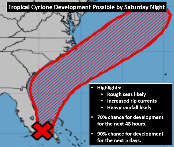
A tropical depression is likely to form by Saturday night, according To NWS-WILMINGTON.
*** Wet Weekend Weather Ahead***
Impacts
Minor flooding for poor drainage and low lying areas
Hazardous boating conditions offshore will increase Sunday
Outdoor event delays or cancellations possible
Heat illnesses possible for sensitive groups with long outdoor exposure times
Forecast Confidence
Moderate
Timing and Strength
Approaching cold front this evening could bring severe wind gusts and heavy rain in the strongest developing thunderstorms.
Localized heavy rainfall totals between 1 and 2 inches possible this weekend with continued showers and thunderstorms.
Temperature change: Highs dropping into the low to mid 80s for Saturday and Sunday.
Heat Indices dropping into the upper 80s to lower 90s.
Low pressure system currently over Florida could develop into a Tropical Cyclone Sunday or early next week.
Weather Summary
An approaching cold front will bring scattered showers and thunderstorms with marginal chances for severe wind gusts, mainly along a line from Florence, SC to Wilmington, NC and northward this afternoon/evening. Localized heavy rainfall is possible and could bring minor flooding to poor drainage and low lying areas across the Cape Fear Region. Cooler weather with the approaching front will bring some heat relief with highs dropping into the low to mid 80s Saturday and Sunday.
A low pressure system currently off the coast of Florida could develop into a tropical cyclone late this weekend into early next week off the Carolina coast. Locally heavy rainfall is likely with increasing seas offshore, which could bring hazardous conditions for mariners.
