

This is part one of a four-part story of the eight-day, 210-mile New River Expedition. This journey was made possible by six men, five of whom call Dillon County home.
I first discovered the New River on my way to a Boy Scout hiking trip to Grayson Highlands with Dillon’s Troop 761. Earl Dutton was on the trip and he explained some of the traits that this river exhibits which differentiates it from other rivers in the East. The river maintains a Northerly course, flowing deeper into the mountains from Boone, NC through Virginia, and into West Virginia before joining the Ohio River. The Ohio River leads to the Mississippi River and so the New River in the end, flows a great loop from NC into the Gulf of Mexico.
This river is one of Earl’s favorite rivers to paddle and upon first glance I could see why. The wide river allows space for canoes, the crystal clear mountain water flows quickly over the pebble river bottom, and rapids scattered along the way always add some excitement. Apart from the river is the view of mountains and rock cliffs along both sides of the river keeping the eyes wandering endlessly. Whereas most rivers flow from the mountains to the coast, the New River remains a mountain river through a gorge dotted with rapids from start to finish.
I had seen the river several times since then and upon crossing the Galax, VA bridge in December of 2016, the conversations began that the New River must be claimed.
The most difficult part of planning is the recruiting process. Few people want to spend their vacation suffering the elements on a river while keeping a schedule. On top of finding the right people for the journey, each of these people has a life and to disappear from that life for an entire week, while coordinating that with the busy schedules of four fellow crewmen. Finding the perfect group to rely on is next to impossible. Navigating the river requires team work and the lack of full commitment by a single person can cripple the crew. Ryan Stephens and I selected the date, and from there the 4-man crew was formed including:
Canoe 1
Lawrence Jordan and Ryan Stephens
Canoe 2
Elijah Drennen and Duncan McLaurin
Canoe 3
Earl Dutton and Ian Bethea (who would paddle with us for the first day of 27 miles and spend 2 nights)
Duncan later recalled that the crew has to be made up of positive and smart people. Positive to find happiness in the misery that no matter what is thrown at us, we find the way forward rather than making an excuse to quit and smart to be able to coordinate with people to pass obstacles and to see the limits of safety.
The New River Expedition is the longest distance that we have dared to tackle and the unknown factor of the New River made the planning process more difficult. Earl Dutton became our advisor in this process and always gave the realistic perspective to compare with my hopeful perspectives. The original plan was to paddle 270 miles from the South Fork, to the headwaters, through NC, VA, WV, past the New River Gorge Bridge to the Gauley Lake in Charleston, WV.
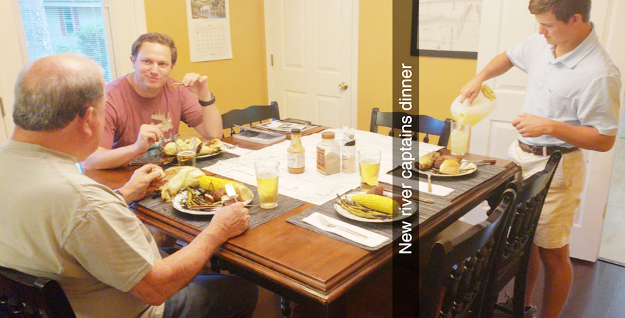
I hosted a “Captain’s Dinner” in early May and presented the plans. Earl listened to the plans and then gave his take on what would be more realistic. The two most important suggestions were to arrange a shuttle to bypass Claytor Lake (20 miles in VA) and Bluestone Lake (10 miles in WV), and that we should stop the voyage in Cunard, WV rather than paddling to the New River Gorge bridge. Whereas most of the earlier river consists of up to class 4 rapids, each with different paths to run and ways to warp around (guide canoe through rapid from land using painter lines), the gorge offers one path through the class 5 rapids and the steep cliffs of the gorge do not allow for warping through the rapids. These adjustments in the plan reduced our itinerary from 270 miles to 240, only to paddle 210 after subtracting lake shuttle distances. Earl also explained as much about whitewater paddling as can be taught from the table. The rest would be for us to learn through trial and error on the river.
Here’s how our 4-man crew packed:
2 tents
4 sleeping bags
4 backpacks
Water filter
Jet boil water heater
2 small propane cans
Fire grate
Rope
4 jugs, 1 gal. each (1 gal./person/day)
2 sets clothes per person (5 sets for Ryan)
Jacket
Raincoat
Flashlights
1 cooler for cold food
4 sets of dinners (frozen vegs and meat)
Cheese,
36 boiled eggs
36 MRE rations
Instant oatmeal
Coffee in tea bags
Telescope
Dry box for room temp food
Dry box for dining supplies
First aid kit
1 pot
1 pan
Spatula
Map
4 life jackets
4 paddles
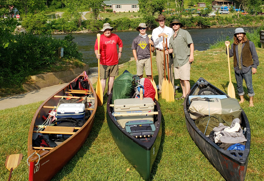
Friday, May 31, was the day we had all been talking about and the crew assembled in Dillon to load the boats. After shopping for food, arranging our possible funerals with Matt Adams (Presbyterian Pastor), and securing the boats, and gear, the convoy departed Dillon, bound for West Jefferson, NC. The ride into the mountains was high spirited and the mystery of the unknown had everyone excited and surely secretly nervous as we questioned if we were actually up to the task. During discussions of the river, Eli asked, “Wait, are we going downstream?” Up to this point Eli was expecting to paddle against the current for 240 miles. He was relieved to know that we would be traveling with the current but he made it clear that he would have paddled against the current if that had been the plan. Eli would later prove himself to be one of the toughest people I know, and his survival skills would pull us through again and again in the miles to come.
We reached the South Fork New River late Friday night and pitched our tents in the dark. The mountain air was shockingly cool at about 55 degrees when we had been experiencing 90 degrees at home. The tents were pitched, and the crew was going to bed while Duncan and I walked to the river bank to have our first look. The river was flowing quickly under a low laying fog and though gentle now, the river would later rage over rapids and rest in lakes over the course of its race to the Gulf of Mexico. “Just let me at it!” Duncan said as he was amped and ready to start chipping away at the miles. It was hard to sleep that night with the certainty of excitement and struggles that we would be submitting ourselves to for the next eight days.
The sun rose, and I started my jet boil to heat water for coffee. Our coffee came in tea bags that can be added to a cup of hot water and coffee was one luxury that we would not skip for the duration of the expedition. Nothing can stir people from the tents and boost morale like hot coffee. Breakfast was our first task of the day, and we blessed the food, thanked God for the opportunity to enjoy His creation, and asked for Him to keep us safe. The crew ate grits, oatmeal, and the daily allotment of one boiled egg for breakfast, and Earl pointed out our destination for day one on the map. We had a 25-mile paddle ahead for day one beginning with 3 miles on the South Fork before meeting the New River headwaters, and from there continuing for 23 miles before reaching our campsite just below the NC/VA state line in Independence, NC.
We packed camp and in no time the boats were lined up at the starting point. Earl and I drove away to park his car at the New River Campground and Canoe so that he and Ian could have a getaway car for Sunday morning. We parked his car and rode back to the starting point where Ryan and Duncan were planning the fair and efficient distribution of gear between the three canoes.
We arrived at the launch point where Ryan immediately fussed about how long we took. After a few final adjustments to the boats, the crew gathered for the launching picture after which, one by one, we slid the boats into the swift South Fork New River. In eight days we will be looking back at this picture from under a tarp, wet and waiting for 22.5 hours for our rescue and the remark will be made, “Look how fresh and happy we looked.” Ryan and I were the first to launch and my canoe drifted with the current while we watched the second and third boats push off. With the sweep of a paddle, the New River Expedition was now underway. (9:20 a.m., June 1, 2019)
Carried by the fast current over the pebble river bed under the great blue sky, morale was at an all time high. Planning an expedition like this is such a fragile process and one single phone call, damaged item, or change in plans can thwart the trip for the entire group. Up to this point I had been worried that something would stop us before we launched the boats, and that if I could just get on the river then all of my cares would be at an end. Now that we were finally on the river, my focus became time vs. distance which would remain my top concern for the next 8 days.
The crew was thrown into navigating white water from the very beginning of the trip starting in the South Fork. These early rapids were short and mild and provided good practice for each crewman to find the rhythm and to train the eye in selecting the line to paddle through the rapids. Our baggage was all secured to the boat using ropes and carabineers so that it would not be lost in the event of capsize. Multiple dry boxes and dry bags were used to keep the essential gear dry. I was so excited to be paddling the New River that I continuously opened my phone box to take pictures, draining my battery, not knowing the breathtaking views and rock faces that we would later pass.
We approached our first class 2 rapid, and Ryan stood to look over the rocks and select our path. As he looked over the rapid, he could see the drop in the river’s elevation as it surged through the rocks. Ryan took his paddle and we braced knees to the gunnel for our first real rapid of the trip. This rapid required fast maneuvering from side to side. In any rapid, the only way to maintain control of the vessel is to be moving at a higher speed than the water. Ryan and I maintained our speed, and I read his movements to be able to react in the way we needed to go. Ryan being in the front of the boat would be my eyes for the next 8 days and in a rapid, there is no time to point out a rock and verbalize a direction to pass it. The communication would be too slow and we would crunch the canoe onto the rocks. The way we would have to paddle would be Ryan selecting the path and myself reacting to his movements. This first rapid was navigated flawlessly and we waited at the end to see the other two boats coming through.
We rounded a bend just past the rapids and beheld the confluence of the North and South Fork, the headwaters of the New River! We had paddled 3 miles to get to this point but it was not until now that the miles count towards the map. We paddled on with added excitement to have passed one of the key landmarks of the voyage.
There were many people on the river on this particular day ranging from kayak fishermen to tubers floating with beer and radios. It was lunch time and Earl called out for us to pause under a bridge to eat. We pulled the canoes up onto the sandy beach and unloaded MRE’s for everyone. MRE meals can be luck of the draw as the meals range from anything as wonderful as brisket or Asian beef strips, all the way to the bland apple oatmeal or vegetable penne. God bless the unfortunate man who gets vegetable penne but does not complain. I received apple oatmeal and Ryan lucked out with brisket. We heated our meals in the boats using the heating agent included with the meals and ate while we drifted in the current.
After a quick moment of consulting with the map, we found that we had only paddled 7 miles for the morning. This pace would not bring us to completing our goal on time and so we paddled on into the afternoon. We paddled on until we reached still water which we knew meant that our first dam, Field’s Dam, was just ahead. With the assistance of the current gone and the wind to our faces, the only way to make it was to crank it out and paddle until we reach the dam. There was no official marker or warning for the dam which was a solid ledge crossing the width of the river. Water poured over the dam like a waterfall and nothing would stop a canoe from being sucked over the dam if it was paddled too close to the currents. Ryan and I were first to reach the Field’s Dam and we stepped from the boat into the soft mud and flopped our way to solid ground to find our path. I could not see a path at first so Ryan called to Duncan and Eli to scout the river right side of the dam. At the time they reached the other shore, I found that the path to portage the dam was on our side at river left. Ryan called to Duncan and Eli to cross back to our side and they shook their heads in frustration as they slid back into the water to cross. They were dangerously close to the dam and Duncan later recalled looking over the ledge and gaining a second wind of strength to power steer the boat across the river without being sucked over the side of the dam. The ledge was too close for comfort and this was the first time of the trip that a crewman’s life flashed before his eyes. The boats were lined up on land when Earl and Ian pulled in. All hands were quick to hold their boat steady for unloading before hoisting it from the river. With 6 people, we decided that the easiest way to pass the dam would be to carry the boats one at a time around the dam, fully loaded, with all 6 people. The first boat lifted with surprising ease and we carried it up the hill and followed a gravel trail back down the hill towards the river. The rocks were large here and the boat moved according to the group so it was most important to move your feet quickly that the boat doesn’t push or pull you over the rocks. It was a dangerous place for ankles and a single rolled ankle would be detrimental to the trip. Duncan told us that his ankles had been worn from sports and so we moved with care to make sure that he had time to get his footing as we carried the boat over the rocks. The crossing was repeated for boats two and three and in no time, we launched back into the swift currents of theNew River. I looked back at the Fields Dam and remarked at how easy the crossing was. Little did we know that this was to be the easiest obstacle of the trip.
I could hear the river roaring ahead and we could see the river sloping down into a rapid speckled with boulders and one main pass with a stationary set of waves, each one being higher than the gunwhale of the canoes. Earl and Ian were ahead of us and they turned to starboard to select their path. Ryan and I feared that we might overtake them and to avoid a mid rapid collision, we pointed to the main pass on river left. The current snatched our boat forward like stepping onto a conveyor belt sidewalk at an airport and we were launched into the fray of the rapids. The bow would plunge beneath the waves but always came up in time for the next big wave. Ryan and I slung our paddles side to side, our knees braced against the gunnels, fighting to stay above water through the swells. The riverbank to our left was a rock wall and so we had nothing to step off to if we were to capsize. I glanced to the rear and saw that both canoes were behind us and we all ended up taking the same path. Any other path through the rapids were shrouded with rocks. The boats dipped and resurfaced, each crew fighting to stay on top. Watching our canoes in the rapids is a fragile sight. The boats are weighted down with the two man crews and gear so there is not a lot of room for the boats to fill up with water. They bounce through the whitewater, halfway submerged at any time, still making the sharp turns to dodge rocks, and somehow are still afloat when the rapid spouts the boats into calm waters. A canoe can only take so much water before submerging and our boat shot free of the rapid with a steep list under the weight of the water that we took on. Ryan and I snatched our green plastic coffee mugs and started bailing water. The coffee mugs were perfect for bailing water from the boats because they were small enough to reach through the gear to scoop water on the floor and each crewman kept their coffee mugs clipped to the back of their seats.
We continued to paddle after the water had been bailed and asked a fisherman for approximate directions. I had a map but being so unfamiliar to the area, we had no reference points to gauge our position. The man told us that we were 4 hrs from our destination and so we knew that if we paddled hard, we could reach the camp by 6:30. Two hours later, a man told us that we were two hours from our destination, with a class 2 rapid not far ahead. We were still on schedule and continued to paddle. The sun was to the West now and the we could see the rapid that we were promised. An inflatable raft was rowing through the rapid at the same time and we passed them on the way through. The promise of camp was becoming more and more real. We rounded a bend and there it was, New River Campground and Canoe. Tents lined the river bank and the smell of campfire cooking made me realize how hungry I was. I could see a General Store from the river as well as a building for showers. At least for tonight we would be living large.
The bank was a steep ledge and so there was no easy place from which we could tie off the boats and carry gear up to the camp. We pulled both boats into a fallen tree branch and tied up there. From there, all of the gear was unloaded and passed from man to man up the hill and to our campsite. Earl and Ian had pulled their canoe from the water and loaded it on the trailer because they would be driving home the next day. We all pitched our tents and explored the site. The people around us were lots of fun to talk with and the different sites consisted of families, groups of friends, couples, etc. The people were always surprised to hear about our goal and I wonder if they believed that we would actually paddle as far as we said that we would go.
Elijah and I walked to the General Store and bought some firewood to cook on. The camp site was well groomed and there was not much wood laying around. We came back to camp and prepared to start cooking when a storm rolled in. The rain came down and didn’t stop for over an hour. Ian, Earl, and I stood under an umbrella and held it over the firewood to keep our cooking wood dry. Duncan and Elijah stood under a tree and claimed to be dryer than us. The sun eventually came out but the rain and wind continued. It was frustrating that we paddled 25 miles with time to cook but couldn’t start cooking because of the rain. The rain did eventually pass and we wasted no time in starting a fire. Chicken thighs, broccoli and cheese casserole, and soup were on the menu for the night. We ate until full and saved the rest to re-heat for breakfast on Sunday morning. All meals would be prepared with a pot and pan and dishes were washed in the river. This was our last chance to shave weight from our boats and so we unpacked our Coleman gas stove, propane tanks, and one extra cooler for Earl to take home. We were now committed to have to start a fire each night to be able to cook dinner. Earl let us borrow his dry box, hot gloves, spatula, and 20′ rain tarp. These supplies would be crucial as our situation develops down stream.
We sat around the fire that night almost hypnotized by the fire while listening to the sounds of camp. A guitar was playing in the distance, children were laughing, and the mountain sides were flashing with lightning bugs. We would be missing these sounds of civilization in the nights to come because starting tomorrow, the campsites would be random riverside hills or islands that we would pitch the tents at. The sky was clear now after the storm and we could see the stars as bright as ever. I took advantage of the shower seeing that it would be my last opportunity to have one for the next 6 nights where we would be going to sleep wet and dirty. A hot shower can mean so much in a place like this. The day was hard but this time at camp was the rest and rejuvenation that we needed.
Sunday morning came and I assembled the jet boil to make coffee. Elijah slept outside by the fire and maintained the flame overnight. He was the first to enjoy a cup of coffee. Earl woke and was immediately passed a cup of hot coffee and he said, “Wow now this is good service!” Duncan made a cup of coffee as we opened the map to plan the day and determined that our goal would be to camp just past the town of Fries, VA. This was the first of our safety vs goal meetings where I tell the distance for the day that we have to make and Duncan points out the hazards and obstacles along the way. “I’m a football man and so I like to live by the quarters.” Duncan said. The trip was then divided into 4 quarters as well as each day. This was the only way to bring the focus of each day to the immediate goal at hand rather than focusing on the overall goal which would have been discouraging. As long as we met our daily goals, then the overall goal will take care of itself.
Our daily schedule: :
6 AM: safety vs goal meeting
breakfast
break camp and load boats
8 AM: launch boats,Q1
PADDLE
10 AM: 1 boiled egg per person, Q2
PADDLE
12 PM: MRE lunch,Stand up break, Q3
PADDLE
3 PM: Snacks, Q4
PADDLE
6 or 7 PM: reach camp site
set camp, cook dinner
10 PM: sleep
Overall Schedule:
Q1: Camp Friday night, first day of paddling, Second night, through Earl’s send off on Sunday morning. NC-VA
Q2: Launch from camp Sunday morning to the town of Allisonia-Claytor Lake, Tuesday (This completes upper New River) VA
Q3: Claytor Lake Dam to Lower Indian Creek-Lake Bluestone VA-WV, Thursday
Q4: Bluestone Dam to Cunard- WV, Saturday
I walked to the boats after breakfast and found them covered with dirt from the storm water runoff. After rinsing out the boats, they were loaded with the gear and we said our goodbyes to Earl and Ian. Several campers gathered at the ledge that and watched from shore while we loaded the boats and curious children asked questions about the supplies. We were clean and fresh after showers and were ready to
take on the river ahead. After a final picture and handshakes, the fleet of now two canoes and four crewmen departed downstream for the unknown. Earl and Ian saw us off as we paddled and we were now past the point of no return.
