

Sunday morning, Day 2- The boats were being loaded to continue the voyage down the New River. Duncan and I looked at the map and agreed that we would set the day’s goal to be setting camp just past the town of Fries, VA (Grayson County) before dusk. After a quick breakfast of coffee, broccoli casserole, and instant grits, we packed camp and loaded the boats. It was time to say our goodbyes to Earl and Ian who were about to return home to Dillon.

The boats pushed off into the current, and I turned around to see Earl and Ian waving from the shore. I felt so far from home being now isolated to our canoes, and I wondered about the culture that our crew would develop now in our smaller size as we work together to continue the journey. Earl was enthusiastic, positive, and knowledgeable – both in camping methods and in the area’s history. The crew enjoyed starting with that insight and now were sent off to claim the rest.
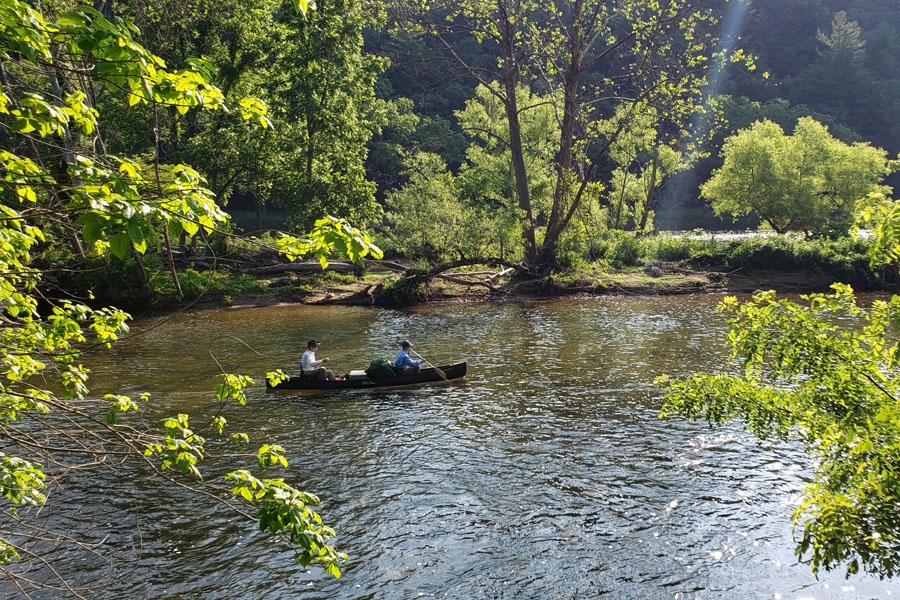
We crossed the VA state line and paddled on for miles and miles. The river winded North through the mountains, deeper and deeper into Virginia revealing new unseen places. I consulted the map with every bridge or landmark to keep acquainted with our location and pace for the day. The current was swift for the morning and spirits were high. Two hours into the morning we pulled the canoes along side and ate our daily allotment of one boiled egg per person, and continued paddling. Ryan and I spotted a bald eagle soaring over the river and through the valley, the first of many. His white head and tail shown in stark contrast against the dark green trees in the background.
Ryan earned the nickname, Eagle Eye, because he could spot and identify any fish from the bow of the canoe. The New River would be a great place to revisit for the purpose of fishing because of the great variety of game that it offers. The New River is predominantly a smallmouth haven but other species such as trout, walleye, and even muskie are caught here. Ryan wanted to bring a fishing pole but I said no because there was little room to spare in the canoe, and I knew that I would be paddling alone had Ryan packed his fishing pole.
On top of one hill was a beautiful stone walled Citadel with a stone tower on each corner that we speculated to be a family cemetery. Ryan remarked that it reminded him of a smaller version of the old European castles that he had seen on a tour. We paddled on through the mountains and pulled over to eat MRE meals for lunch. We decided that it would be important to stretch our legs and stay on land for a few minutes during lunch to break the monotony of paddling in the same position all day long. We paddled on after lunch and after passing the HWY 94 bridge, we knew that we were close to Fries and morale was high.
Things changed just around the bend. The river spread from 100 yards in width to at least 250 yards in width and the current came to a virtual standstill. As our little fleet rounded the bend it came to view that we could see 3 miles ahead downriver with the same wide river and very little support from the current. The wind kicked in and billowed directly against our two boats. The focus was simply to paddle one stroke at a time to a goal that looked like it was never moving closer. More force was pushing against us by the wind than with us by the current. I looked behind me and could see Duncan and Eli swinging their paddles side to side. Their canoe was not as streamlined as my canoe, and they had to exert greater effort to keep up. Each boat had to pull themselves through and there was no other way but forward. The wind followed the valley, and we tried hugging the riverbanks to find the path of least resistance. I had no idea as to how long this section without current would last, and we prayed that the wind would break for us.
We passed the next bend and noticed how deep the water was here and that we must be in the backwaters of the Fries Dam. Clouds gathering overhead dimmed the sun, and we could soon see the ledge where the water poured over the Fries Dam. (Mile 54) This dam was much higher than the Fields Dam and beyond the dam, we could see river continuing past the town of Fries which is built up along the mountain side. A steep cliff blocked both sides of the dam, and so the portage would have to he done by walking our gear up and around the mountain, across to the town of fries, and into the river downstream from the dam. This would be over a mile walk carrying gear and with the slogan, “forward motion only” we got started. Duncan, Ryan, Eli, and I all picked up our backpacks and coolers before starting up the hill. We reached the top from where we could see the path and realized the impossibility of making the pass before dark. The new question at hand is, if we cannot cross, then where will we stay tonight? Duncan and I walked to a nearby community asking either for a shuttle or permission to camp and found no help. We walked back to the canoes and decided to camp where they lay. The boats were moved to be hidden behind a dirt mound, and the tents were to be pitched underneath a cluster of trees. This site was private land, and it was uncomfortable to be there but it was our only option.
A storm was building over the town of Fries, and the sky grew ominously dark. The wind picked up, and birds sought shelter. Eli collected enough firewood to start cooking, and I mixed chopped beef with mixed vegetables in a pan over the fire. Ryan and Duncan hurried to pitch the tents, and draped Earl Dutton’s tarp over the two tents. Camp was secure and tied down, and the lightning cracked overhead. Duncan called to me, “is the food cooked?”
“Just a few more minutes,” I replied, as I cooked by the fire, all the while assuring myself that I know people who have been struck by lightning and lived to tell about it.
The wind and lightning grew more intense and as soon as the rain hit I picked up the pan and sprinted to the tarp. Duncan and Eli held up a corner for me to run through.
There was no space inside of the tarp, and Ryan stood in the middle holding it up as much as he could while we ate. We thanked God for the food, for bringing us this far, and to keep us safe in this place from the weather and from people. We gave a shout out to Earl for sharing his tarp with us knowing that we would eventually run into this situation.
The crew served each other and ate dinner under the tarp. Rain rolled down the tarp, and even though we were not being rained on, we were soaked by whatever part of us touched the tarp at any moment. We ate with our backs to the tarp, and the cold rainwater rolled down our backs. The mood was poor at an all time low, more because we did not know how to pass the dam in the morning than because of the weather.
We finished dinner and slid the dirty dishes from under the tarp into the rain. It was only 8 p.m., and we turned in to sleep for the night. Everyome crawled into the sleeping bags wet and I assumed that from here on I might as well give up on the prospect of staying dry.
Monday morning came, and the rain had stopped. I was relieved to see that all of our gear was still present, and so I proceeded to heat water for coffee. Duncan and I consulted the map for our safety vs goal meeting and determined the goal for today would be for us to camp at the shot tower in Austinville, VA. To get there would mean a 22- mile paddle passing class 2, 3, and 4 rapids as well as three dams; Fries, Byllesby, and Buck.
My next task was to run into town and find someone with whom to arrange a shuttle to get our crew and supplies around the dam. The crew would break and pack camp while I was away, and I was not to return until transportation was arranged. It was a mile and a half run into town even though it looked to be so close from our camp. By 7:30 I was waiting on the doorstep of city hall to find help. The city hall never opened, and so I explored. I covered Main Street, and found a sweet lady in a cafe who gave me the Mayor’s phone number. I called the mayor who referred me to a city councilman, who referred me to New River Outdoor Adventures who didnt answer. I continued to search downtown and went to the library which was unlocked, but with no staff. I walked around looking for someone and ended up in an empty pool room/bar. My phone battery was low, and so I found pen and paper behind the counter to write down my phone numbers for Mike’s shuttle that would later be important for the trip. Looking out over the river to the dam I could see the crew all the way from town. They were specks moving about the campsite packing up and surely getting anxious by the wait. I thought to myself, “this group from so far away with no connection to the area, what are we doing way up here?” The crew was our little piece of Dillon and with the crew is home for the week.
Finally I received a call from New River Outdoors, and he graciously offered to provide the shuttle. I sprinted back to
camp, and we moved the gear up the hill and to the road to await transportation. When the van arrived, we loaded our gear and eagerly hopped inside for a ride. The boats and gear were unloaded just downstream from the dam, and we noticed that we had lost a life jacket. The driver said that we can buy one at his shop when we pass it one mile downstream. Duncan inquired with our driver to find out what exactly we should expect for the day ahead. He told us that we would first run into a 2 mile stretch of class 3 rapids, that the Byllesby Dam Portage was possible but difficult, and that Buck Dam is even worse with a class 4 rapid in between.
This was not good to hear but the problems would be addressed as they came. We reached the New River Outdoors store and walked up the hill to purchase a life jacket but found our life jacket on the table. Our driver had returned to our camp to find the life jacket and left it here knowing that we would be on our way. We decided to stay for a few minutes and order sandwiches from the deli and restock our water supply. The sandwiches restored morale and even though we lost precious time, these sandwiches would give us the encouragement that would later be needed to make it through arguably the longest day of the trip.
It was not long before we reached the rapids that we had been warned about. The river made a noticeable drop in elevation through the rapids to the next bend, and there were several falls along the way. Ryan and I pulled over to make sure everything was secure, and then we pushed off to make our approach. Ryan and I paddled hard as we skirmished through the entry rocks to where the first series of falls began, and my nerves were tense knowing that we could break bones or worse, the boat in the next few seconds. Communication was key as we made the turn into the drop. With a final stroke of my paddle, the bow plunged way down, and Ryan was immersed into the white water. The bow came up for just a moment for the water inside to settle before plunging over another drop, and another. Ryan and I were soaked by the spray of the white water but the bow of the canoe miraculously came up each time.
Our canoe was full of water, and Ryan and I balanced carefully as we paddled to the shore to start bailing water. Ryan and I started bailing water when the bow wedged into the ground. Ryan and I looked upriver while Duncan and Eli paddled the rapids. It is almost scarier to watch a boat going through than to be in it yourself because the canoe looks like it is just barely holding on to the surface and there is nothing we could do to help. Capsizing in a rapid like this would surely mean broken bones, and it was a relief the see their canoe shoot out of the end of the rapid, rails barely visible above the surface. Both boats were bailed, and the paddling continued.
The river continued on for several bends until we reached still water, surely the backwaters of the Byllesby Dam in Carroll Co, VA. The wind blew against the canoes, and we clung to the tree line to buffer the wind as much as possible. When we reached the dam, we realized that the dam was much larger than what it looked like on Google Maps. This dam was far larger than we anticipated, and we were soon to find out that the portage route would be much farther than we realized as well. First things first, each crewman took a backpack and started walking. We walked uphill until we passed the dam wall and then began the long descent back to the river on the lower side of the dam. The trail switched back and returns to the river just shy of half a mile. We walked back up the hill to make the second trip for the coolers, MRE bag, and other supplies. By the time Eli and I returned to the high side of the dam, we had carried gear for 2 miles worth back and forth, and now were here to carry the first canoe. We hoisted the canoe to our shoulders and carried it up the hill. We set our goal to be the top of the hill before our first break. We reached the top and set the canoe down for a break. Ryan joined, us and after we started walking again, he reached as high as possible to support the middle of the canoe. I thought about the uneven weight placement and knew that a pulled back would absolutely stop us from reaching our goal, and so we treaded carefully over the rocks. At any point where we saw grass, the canoe was placed on the grass, and we pulled the boat with ropes around our waist like a sled team. This was worth doing even for a gain of only 10 yards. From the height of the ledge I could look down and see where Duncan was guarding and sorting gear for reloading. We used the ropes to rappel the canoe over the ledge to Duncan but the trees were too thick and the bow was getting stuck in the brush so we hoisted the boat back up and continued on the trail. We finally reached the river and set the boat down. After a quick break, we walked a half mile back up hill to bring the last canoe. Carrying the last canoe was as difficult as the first but our energy immediately returned when we reached the river and pushed off again. There was a feeling of triumph across the crew but we all knew that another dam lingered ahead two miles down river.
The next bend of the river was Buck Shoals, a class 4 rapid that according to a guide book I read, was warned not to paddle through. We guided the boats through these rapids using our painter lines from the safety of the rocks bordering the rapid. The current took control at some points, and we had to scramble ahead across a few rocks to keep up. These rocks were dangerous for twisting an ankle or slipping on the smooth surfaces of a rock. Elijah and I guided the boats and passed the ropes to Duncan and Ryan who were ready in case we ever came to a rock that was a dead end.
We made it through Buck Shoals and boarded the canoes to paddle onward. Just downstream from the rapid was still water, the backwaters to the Buck Dam. As before, we paddled into the wind without the assistance of current until we reached the dam. Buck Dam was even less user friendly than Byllesby Dam, and the access to get to the road was a 50- foot slope of puff mud with a narrow gravel pile that was no wider than the canoes. Two on each side, the crew trudged through the mud sinking to our knees in each step, all the way to the top of the hill, then returned to the base and drug up the next canoe through the mud that we had already mushed up. I walked ahead to find the access point from which we could launch the canoes down stream and found that again, it was almost half a mile.
I pleaded for help with an Appalachian Power employee who apatheticly refused even to share a dolly to roll the canoes. We had paddled in the heat all day, and I feared that this crossing would break morale after the struggle at Byllesby. Appalachian Power owns the land around the dams but since the river is public, Appalachian Power is required to provide a Portage route. They don’t care how long or unreasonable the route may be as long as it is documented that they share a passage.
Once our boats were on the road atop the mud hill, the Buck Dam Portage was easier that Byllesby primarily because of our teamwork. We worked as a group to carry each boat one at a time to the halfway point and then again to the finish line. It was here that the crew became a well oiled machine and exceeded Duncan’s goal of reaching the finish line by 5 p.m. We celebrated with propel water and Vienna sausage before launching the canoes into the last stretch of paddling.
Back in the swift water with nothing but unobstructed river ahead, the crew paddled onward with renewed determination to reach our original goal at Galax,VA. We were willing to paddle until nightfall if we had to but by the assistance of the current, that would not be necessary. We paddled past rock cliffs of a thousand feet and were un phased by the rapids we encountered. The sun hung low in the sky, and the valley reflected radiantly with the warm light on the river and the trees. Ryan pointed out a bald mountain in the distance with a herd of white horses in the distance, and we passed several boats of muskie fishermen.
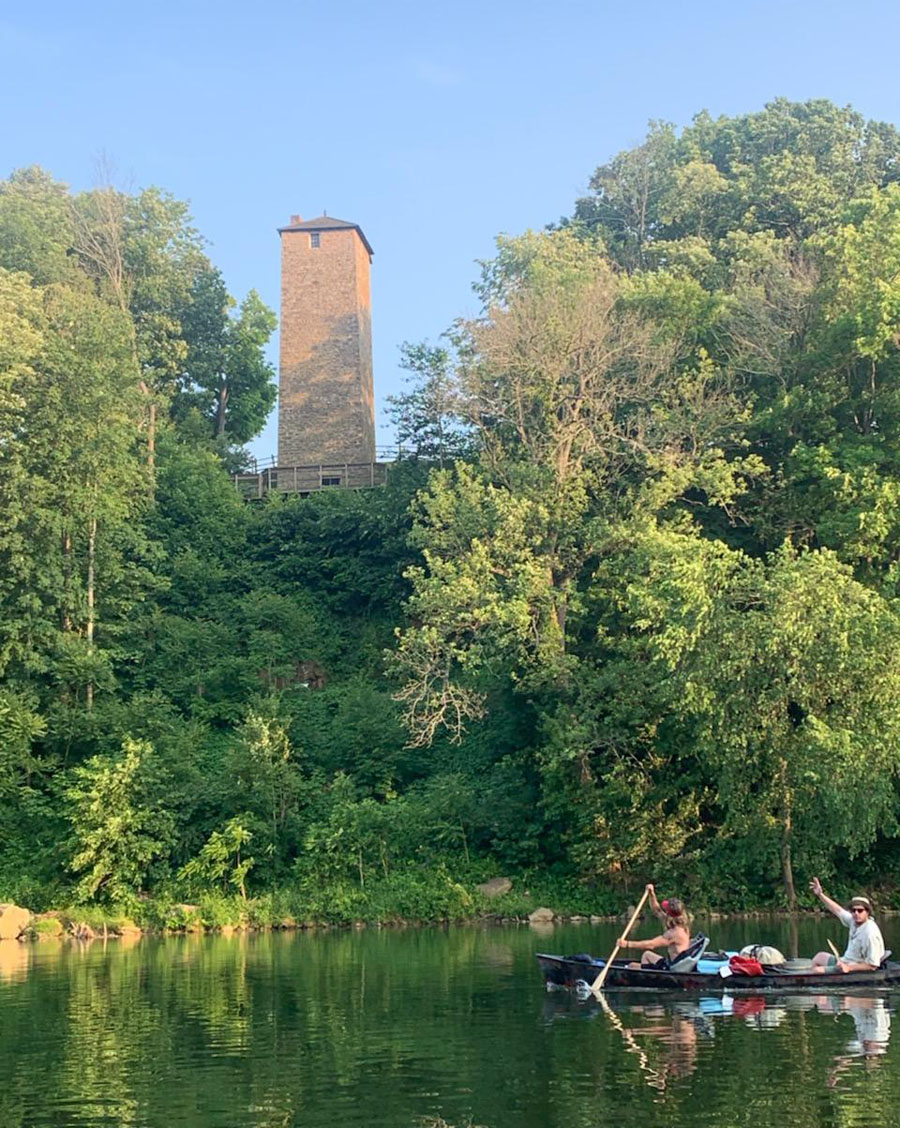
We had one last rapid to navigate at about the time that the I-77 bridge near Galax, VA came to view and there, our destination for the evening. The Shot Tower State Park was just downstream from the I-77 bridge, and we passed it before making camp. The shot tower was used in the Civil War by the Confederacy to make their lead musket balls. In the top of the stone tower, the molten lead would be dropped towards a pale of water at the base. As the drop of lead falls, it forms into a perfect circle before hardening in the cool water.
The tents were pitched along the river banks overlooking the river, I-77 bridge, and a farm with rolling hills and a red barn across the river. (Mile Marker 76) Ryan and Elijah cooked Hamburger Helper® for dinner with sides of soup and bread. The crew was exhausted and watched the sunset while enjoying a triumphant dinner and hard earned relaxation. Our soaked bedding gear hung from the branches, and we hoped that maybe we would sleep dry that night. We finished the evening with cigars and watched in wonder while the mountains flashed with lightning bugs.
We deserved a treat on Tuesday morning, and the usual breakfast of coffee and oatmeal was served with sausage wraps. Duncan and I laid out the map in the sand and plotted the day. Around the bend was a Class 4 rapid called Foster Falls that we planned to rope the boats through, and 14 miles past that, our prearranged shuttle would pick us up in Allisonia, VA and take us on our 20- mile portage of Claytor Lake.
The approach to Foster Falls was daunting and taken with caution until we reached the falls. You could not see over the ledges where the falls were and it is too easy to be pulled into the currents. We pulled the canoes against the shore so that Duncan and Ryan could walk around the rapids on land while Elijah and I roped the boats through the rapids. We passed Foster Falls with ease and continued paddling.
We paddled through eight more rapids before reaching Allisonia, VA.(Mile Marker 89). Ryan and I reached the ramp and pulled the canoe onto the shore. I looked up river and saw Elijah and Duncan on an island. I thought that they stopped for a bathroom break but it was actually that Elijah had uncovered a care pack that someone had left on the river.
When they caught up, Elijah stepped from the boat holding bags of snacks and goodies for us that he unloaded from the care pack. Elijah said that there was a pole in the ground on the island with a vulture feather attached and Elijah assumed that the feathermeant for him to “scavenge here.” He handed out fruit punch, candy, jerky, and more. We waited in the parking lot enjoying our new snacks with lunch and waited for our shuttle to arrive that would bypass Claytor Lake and send us off into Quarter 3.
